파일:Korean war 1950-1953.gif
미리 보기 크기: 387 × 600 픽셀 다른 해상도: 562 × 871 픽셀
원본 파일 (562 × 871 픽셀, 파일 크기: 1.32 MB, MIME 종류: image/gif, 반복됨, 20 프레임, 30 s)
파일 설명
| 설명 |
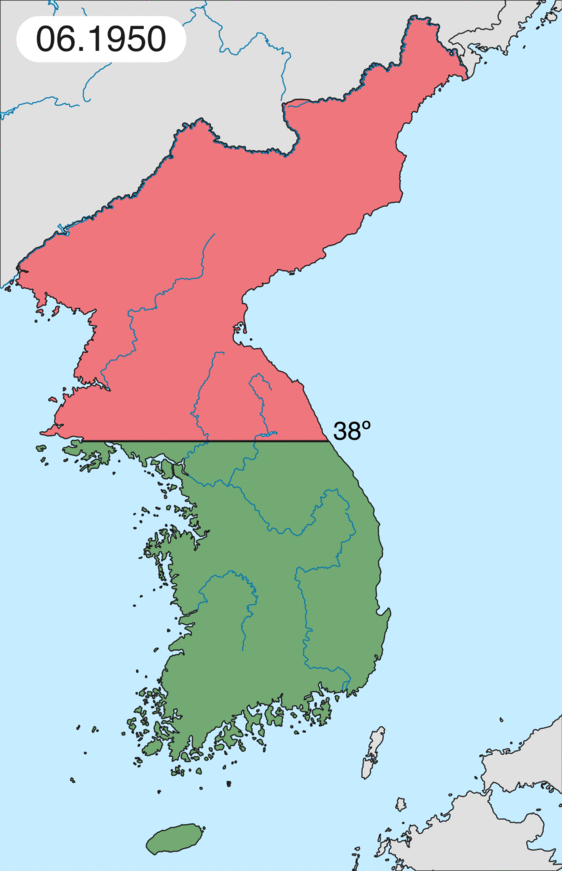
Deutsch: Karte des Koreakriegs von Mai 1950 bis Juli 1951, abgebildet:
English: Map of Korean war from May 1950 to July 1951, showing:
Chinese and communist forces (Soviet Union) (light red) North Korean forces (red) South Korean, US and United Nations forces (green). Français : Carte de la guerre de Corée de mai 1950 à juillet 1951, montrant:
Les forces chinoises et communistes (Union Soviétique) (rouge clair) Les forces nord-coréennes (rouge) Les forces sud-coréennes, des États-Unis et des Nations unies (vert). Italiano: Mappa della guerra di Corea dal maggio 1950 al luglio 1951, rappresentante:
Le forze cinesi e comuniste (Unione Sovietica) (rosso chiaro) Le forze nord-coreane (rosso) Le forze sud-coreane, degli Stati Uniti e delle Nazioni Unite (verde). |
| 날짜 | |
| 출처 | 자작 |
| 저자 | Leomonaci98 |
라이선스
나는 아래 작품의 저작권자로서, 이 저작물을 다음과 같은 라이선스로 배포합니다:

|
GNU 자유 문서 사용 허가서 1.2판 또는 자유 소프트웨어 재단에서 발행한 이후 판의 규정에 따라 본 문서를 복제하거나 개작 및 배포할 수 있습니다. 본 문서에는 변경 불가 부분이 없으며, 앞 표지 구절과 뒷 표지 구절도 없습니다. 본 사용 허가서의 전체 내용은 GNU 자유 문서 사용 허가서 부분에 포함되어 있습니다. |
| 이 파일은 크리에이티브 커먼즈 저작자표시-동일조건변경허락 3.0 Unported 라이선스로 배포됩니다. | ||
| ||
| 이 라이선스 틀은 GFDL 라이선스 변경의 일부로 이 파일에 추가되었습니다. |
이 라이선스 중에서 목적에 맞는 것을 선택하여 사용할 수 있습니다.
파일 역사
날짜/시간 링크를 클릭하면 해당 시간의 파일을 볼 수 있습니다.
| 날짜/시간 | 섬네일 | 크기 | 사용자 | 설명 | |
|---|---|---|---|---|---|
| 현재 | 2020년 2월 17일 (월) 05:20 | | 562 × 871 (1.32 MB) | commonswiki>Leomonaci98 | Graphic update |
이 파일을 사용하는 문서
다음 파일 1개가 이 파일과 중복됩니다 (자세한 정보):
- 파일:Korean war 1950-1953.gif (위키미디어 공용)
다음 문서 1개가 이 파일을 사용하고 있습니다: